Skip to content Transforming your infrastructure into living assets

Digital Twin

Digital models and classified point clouds for anomaly detection and infrastructure risk management

Create highly accurate, data‑rich virtual replicas of infrastructure assets

Sixense’s digital twin services enable the creation of highly accurate, data‑rich virtual replicas of infrastructure assets, generated from high‑density LiDAR, photogrammetry, and multi‑angle imaging.
 
These digital twins provide detailed representations of structures such as powerlines, rail networks, roads, bridges, tunnels, dams, and urban environments, supporting design, analysis, and maintenance activities with precision. By combining advanced surveying technologies—including airborne, mobile, and ground‑based LiDAR—with high‑resolution 360° imaging and RGB, NIR, or thermal data, Sixense delivers tailored digital twins capable of supporting complex engineering requirements across diverse sectors.
 
Sixense mapping digital twins railway station 3D mesh
 
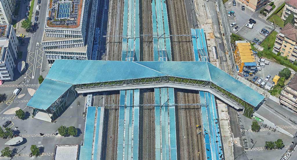
In infrastructure design and planning, Sixense’s digital twins are used to create accurate digital terrain models (DTMs), 3D models, BIM‑compatible datasets, and immersive city‑scale meshes. These models help engineers simulate design scenarios, assess environmental impacts, plan new construction, and ensure project feasibility with real‑world accuracy. Applications include planning and constructing new powerlines, developing road and rail expansions, and integrating new structures into existing urban contexts through photorealistic visualisation and thermal or infrared survey analysis.
 
Digital twins are equally powerful for asset maintenance and lifecycle management. By providing a living, up‑to‑date digital representation, they support vegetation risk assessments around powerlines, ballast and track condition analysis for railways, and precision monitoring of bridges, tunnels, and dams.
 
Sixense mapping digital twins bridge 3D models
 
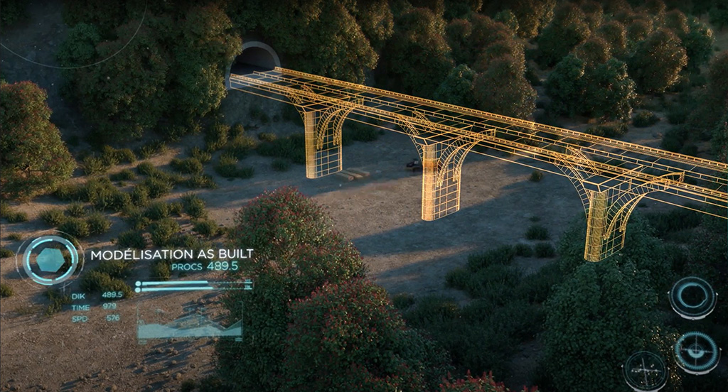
Sixense’s modelling and monitoring expertise helps asset owners evaluate structural behaviour, detect anomalies, anticipate risks, and optimise predictive maintenance strategies. This capability aligns with Sixense’s broader digital transformation mission—leveraging rich data, AI, and monitoring technologies to keep infrastructure safe, efficient, and sustainable.
 
Finally, our digital twin services play a central role in improving operational performance and decision‑making. Integrated within their broader digital ecosystem – and supported by advanced data management and AI – they enhance traceability, support automated reporting, and streamline maintenance planning across asset portfolios. By converting complex field data into actionable insights, Sixense empowers infrastructure owners and operators to better understand their assets, reduce operational risks, and extend service life through informed, data‑driven decisions.

Applications

Powerlines

LiDAR acquisition services and customized data processing for the maintenance, construction and analysis of your powerline and other energy infrastructures

  • Creation of digital twins for network maintenance and optimization
  • Detection, analysis and monitoring of dangerous vegetation
  • Planning and construction of new lines
  • Customized services for engineering firms and consultancy

Railways

Highly accurate, ultra-dense, non-invasive digital twins for modelling, analyzing and maintaining airborne and railborne rail networks.

  • Topographical survey of the network with absolute accuracy up to 2 cm
  • 3D modelling of railway infrastructures
  • Analysis and maintenance (ballast, vegetation, risks, etc.)
  • MLS + ALS combination for surveying tunnels and bridges

Roads

High-quality aerial surveys and mobile mapping for road infrastructure design and management

  • High-density LiDAR acquisition for precise terrain modelling
  • BIM integration for optimum project planning and management
  • Drawings and road plans from 1:200 scale upwards
  • Precision modelling and DTM for new buildings and earthworks
  • As-built 3D drawings of infrastructure and engineering structures

Urban areas

Photorealistic 3D models of urban areas, combining LiDAR technology with multi-angle RGB, NIR and thermal imagery

  • Pentacam acquisitions for a complete immersive experience
  • High-precision and high-resolution 3D mesh generation
  • Thermal imaging surveys for heat islands detection
  • Infrared surveys to study vegetation
  • Impact assessment and integration of new projects

Bridges, viaducts, tunnels, dams and other infrastructure

Very high-density LiDAR surveys of sites and infrastructure requiring precise and detailed analysis

  • Nadir and oblique surveys for scanning from all angles
  • Combination with thermal and infrared imaging
  • Surveying tunnels and bridges with mobile mapping technology
  • Combined aerial, mobile and ground surveys

Our solutions

Very high precision airborne LiDAR survey

  • Non-invasive LiDAR and photogrammetric acquisition services
  • Nadir and oblique views of the infrastructure
  • Exclusive LiDAR FNB (forward + nadir + backward) data capture technology for complete structure scanning

Mobile LiDAR survey for tunnels and structures

  • Point cloud capture and very high-resolution 360° images
  • Ideal for tunnels and other structures that cannot be accessed by air
  • Can be combined with airborne and static surveys

Creating a digital twin

  • Very high-density point clouds classified and colored in RGB
  • Very high resolution orthophotos
  • Digital terrain models, surface models, etc.
  • 3D mesh

Infrastructure analysis and maintenance

  • Creation of 3D models for anomaly detection and risk management
  • Optimized solutions for planning and monitoring works
  • Vegetation detection, distance measurement, analysis and risk monitoring.
  • Other maintenance services (ballast, volumes, rock falls, cracks, etc.)

BIM

We create 3D models and BIM models using LiDAR and photogrammetric data to generate a comprehensive, reliable inventory that facilitates infrastructure operation and maintenance.

Our advantages

  • 4 sensors of the latest generation of LIDAR and image sensors, specially designed for creating digital twins, corridor surveys and city modelling.
  • Over 20 years’ experience in 35 countries
  • Non-invasive approach
  • Comprehensive survey of the infrastructure and its surroundings

To find out more about our expertise,
visit the Sixense Helimap website.