Skip to content Transforming your infrastructure into living assets

Satellite Monitoring (Atlas InSAR)

Monitoring ground motion and infrastructures stability from space

Advanced satellite-based Radar Interferometry

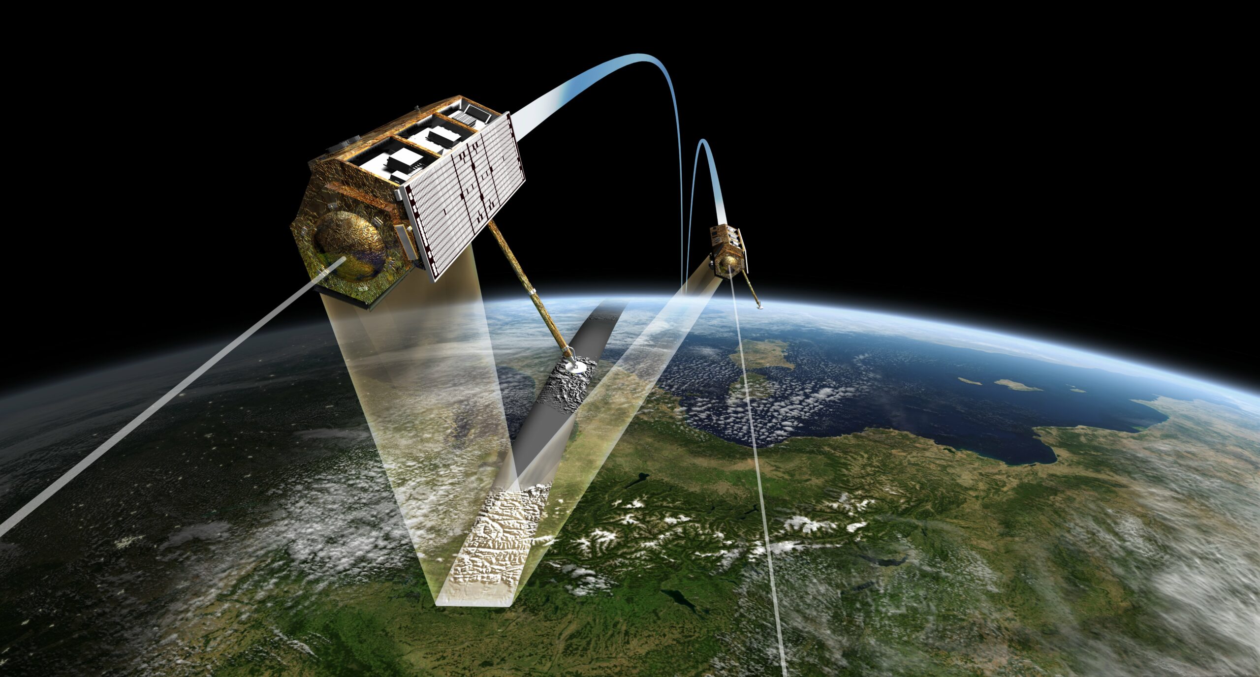
Atlas InSAR is Sixense’s advanced satellite-based Radar Interferometry solution, designed to measure ground deformation and structural stability with millimetric precision.
 
By analysing differences between repeated radar satellite images, Atlas InSAR can detect even the smallest movements of the Earth’s surface and built assets. This technology enables the generation of highly accurate, long-term deformation trends over large geographical areas, making it suitable for projects ranging from urban infrastructure to remote industrial facilities. With no need for on-site equipment, Atlas InSAR provides a powerful and continuous layer of insight that complements traditional geotechnical and structural monitoring systems.


One of the key strengths of Atlas InSAR is its ability to provide millions of measurement points across large areas of interest, offering both a broad overview and targeted detail.
 
This capability is invaluable at every stage of a project’s lifecycle – during early design and planning, throughout construction, and into the operational and maintenance phases. Whether the requirement is to understand historic ground movement, monitor active construction impacts, or assess long-term asset stability, Atlas InSAR delivers data that supports confident decision-making. The system can also reveal differential settlement, subtle slope movement, or structure-specific displacement patterns that may not be detectable using ground-based monitoring alone.
 
As a remote sensing technology, Atlas InSAR does not require physical access to sensitive, hazardous, or difficult-to-reach locations, making it not only safer but also highly cost-efficient. It can significantly reduce the need for extensive on-site instrumentation networks, while still providing reliable and high-resolution movement data. This capability is increasingly important in managing the risks associated with both natural and human-induced ground motion, including subsidence, landslides, mining activity, tunnelling works, and changes in groundwater conditions. As infrastructure networks expand and environmental pressures grow, Atlas InSAR is playing a crucial role in helping operators and project teams detect early warning signs, mitigate risks, and maintain the resilience of critical assets.
 

Principles of satellite monitoring

Interferometric synthetic aperture radar (InSAR)

Radar interferometry is a satellite remote sensing technique capable of measuring millimetric motion of terrain over wide areas.

InSAR uses two or more Synthetic Aperture Radar (SAR) images acquired over the same area at different times to derive landscape topography and detect ground deformation patterns.

A SAR sensor transmits electromagnetic pulses toward the Earth’s surface and records the backscattered signals. Unlike optical sensors, SAR can operate both day and night and under all- weather conditions.

When several measurements are compared the difference indicates ground deformation over time.

For any ground point, satellite time series enable the follow-up of phenomena every few days during the monitoring period.

A step further to get millimetric precision

Atlas is Sixense’s InSAR processing chain designed to monitor geotechnical and structural deformations.

The Atlas processing chain is based on the most advanced PSI (Persistent Scatterer Interferometry) methodology and takes conventional InSAR a step further to achieve millimetric precision of the ground motion readings.

The PSI technique requires an initial stack of at least fifteen SAR images to reach millimetric precision. The algorithm identifies common points (Persistent Scatterers) within the stack of images from which accurate measurements can be derived throughout the study period.

The outputs of Atlas processing are maps presenting accumulated displacement and mean velocity deformation throughout the study period for each measured point.

Applications

Atlas InSAR is a technology that makes industries and communities safer, operations more efficient, and the understanding of ground behavior more precise. It is has many industry applications:

  • Civil Engineering:
    Monitor the stability of entire cities as well as tunnels, bridges, buildings, viaducts, and other key infrastructures. Control ground deformation at every stage of a project, from design to construction and maintenance.
  • Mining:
    Extensively used in both open-pit and underground mining to remotely track ground deformation across critical assets. Our tools and expertise support decision-making throughout the mining lifecycle, from exploration to operations and mine closure.
  • GeoHazards:
    Detect precursor slope movements and assess ground impacts after events such as floods or heavy rainfall. Through Atlas InSAR Sixense helps clients anticipate, monitor, and mitigate geohazard and climate-related risks, fostering safer and more resilient territories for future generations.
  • Oil & Gas:
    Monitor ground deformation linked to extraction, injection, or storage activities. Ensure pipeline stability and support compliance with HSE requirements.

Characteristics and benefits

Millimetric precision: up to 1 mm/year and 2-3 mm precision on single measurement points

Non-invasive system: remote solution without site intervention and free of maintenance

High measurement frequency: 3, 4, 6, 8, 11 or 12 days between acquisitions depending on satellites

High density of measurement points: more than 50,000 points/km2 in urban areas

Coverage of large areas: monitoring over remote and very extensive areas (thousands of sq. km)

Retrospective analyses: past ground motion analysis from 1992 using archive imagery

On-demand monitoring: update frequency adjusted to magnitude of motion and project needs

Forensic analyses and litigation support: a valuable tool for technical investigations and legal cases

Integrated expertise: Sixense stands out by combining InSAR data with ground instrumentation, offering a unique and comprehensive monitoring solution

Web GIS platform: User-friendly interface for a quick and easy storage, handling and interpretation of the information

The additional benefits of using our Atlas InSAR solution

A unique competence combining InSAR data and Ground Instrumentation data

• Integrated ground and space sensor monitoring solutions
• Applicable to many industries
• More than 800 engineers dedicated to construction
• 10+ years of radar data processing expertise

Atlas InSAR - a high quality processing chain

• In-house InSAR solution developed in 2004
• Constantly evolving
• Compatible with all satellite sensors
• Adapts to new SAR data volumes
• Ready for next-generation missions

Beyond Monitoring - advanced web-GIS platform

• Actionable InSAR data
• User-friendly and intuitive
• Customised insights
• Advanced analytics and filtering tools
• Multi-sensor integration
• Holistic asset control