Atlas InSAR is a satellite-based deformation monitoring system that measures ground and infrastructure movement from space.
The Atlas InSAR solution from Sixense is a state-of-the-art satellite-based deformation monitoring system that uses Interferometric Synthetic Aperture Radar (InSAR) to measure ground and infrastructure movement with millimetric precision from space. By processing radar images acquired by satellites, Atlas InSAR generates millions of data points across large areas, in some cases covering entire cities with each image, providing a comprehensive perspective on ground and structure deformation and structural stability without the need for on-site sensors or physical access to the monitored zone. This remote sensing approach delivers high-resolution insights throughout the lifecycle of a project — from planning and construction to operations and long-term maintenance — while remaining cost-efficient and adaptable to project demands.
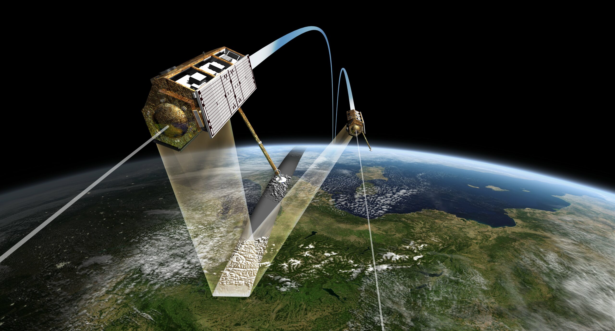
Atlas InSAR works by analysing repeated satellite SAR images over the same area to detect subtle changes in the earth’s surface and built environment over time.
Advanced processing techniques — including Persistent Scatterer Interferometry — are applied to these image stacks to derive precise deformation maps and time-series data for each measurement point. Monitoring frequencies can be tailored to project needs, with updates delivered weekly, monthly, quarterly or on another schedule that reflects the criticality of current activities. These flexible monitoring programs help asset owners, contractors adn engineers comprehensivelyunderstand the performance of their assets.
For areas where reflections are difficult to acquire, or for monitoring locations at specific points, Sixense ACR (Automatic Corner Reflectors) can be installed
Atlas InSAR’s satellite-based deformation data is fully integrated into Sixense’s Beyond Monitoring platform, bringing millimetric-precision surface movement insights together with all other site instrumentation for a complete and comprehensive overview of ground and asset behaviour. By delivering millions of InSAR measurement points alongside data from in-situ site based sensors, Beyond Monitoring transforms complex satellite outputs into actionable, visualised information that engineers and stakeholders can analyse in real time, apply advanced filtering, and correlate with other datasets for more robust risk management and decision-making. This seamless integration enhances the value of Atlas InSAR by embedding its wide-area deformation maps and time-series directly into a unified monitoring environment, helping teams understand evolving conditions holistically throughout the project lifecycle.
Atlas InSAR is an invaluable tool across industries where understanding ground motion is essential — from civil and infrastructure projects like tunnelling and urban development, to mining operations, tailings dams, and risk-prone slopes and embankments. Its ability to provide early warning of accelerating movement, monitor settlement beyond predefined zones, and support risk mitigation strategies helps project teams make better decisions and enhance public safety. When integrated with Sixense’s broader data platforms, Atlas InSAR delivers actionable insights that strengthen risk management, optimise ground instrumentation strategies, and drive more efficient, informed asset stewardship.
Continuous ground deformation monitoring from space
Our Atlas InSAR advanced processing chain is designed to work with any type of satellite radar (SAR) images.
Sixense teams can task SAR satellites to acquire images over any site every few days, enabling the development of customized monitoring programs that provide ground and asset motion information and support clients in managing different project situations.
Different satellites will be tasked depending on site and motion characteristics. Atlas InSAR can work with X-, C- or L-band sensors to ensure the most reliable information is obtained for each project.
New constellations are being launched and very soon daily imagery will be available for real-time satellite monitoring programmes at a fraction of the cost of traditional monitoring.
Use case examples
Monitor the impact of construction works
Atlas InSAR monitoring can be applied during the construction phase of any project, providing millions of measurement points with millimetric precision.
The area covered by InSAR analyses can extend beyond the defined Zone of Influence (ZOI), making it a valuable tool for detecting deformations that exceed the expected perimeter, such as those resulting from dewatering activities. This makes Atlas InSAR an ideal solution for addressing subsidence claims and complementing in-situ instrumentation.
Monitor tunneling activities: ground settlement due to volume loss
Atlas InSAR monitoring is particularly suited to monitor ground surface displacement resulting from tunneling activities and to measure its impact on existing buildings and infrastructures.
During tunnelling advancement, InSAR Atlas monitoring solutions are used to monitor ground settlement due to volume loss, verify surveying reference points and map any widening of the settlement outside the calculated ZOI.
Risk reduction in mining and tailings dams
Atlas InSAR Monitoring enables customized monitoring programs to support mining activities.
It can track ground motion at both underground and open-pit mining sites and can be used to ensure the stability of critical infrastructures, including tailings dams, waste dumps, access roads, and pipielines.
By providing regular, high-precision measurements, Atlas InSAR helps mining operators identify potential risks early, optimize safety measures, and reduce operational and environmental impacts.
Early warning tool: detect precursor motion to landslide and slope failures
Atlas InSAR monitoring is an effective tool for detecting precursor movements leading to landslides or slope failures across large areas, such as highways, railways, and pipelines, as well as in remote or critical infrastructure, including mines, tailings dams, and bridges.
Non-linear movements or acceleration in motion can be identified, enabling the implementation of early-stage mitigation measures to reduce risks and enhance safety.
Long-term maintenance
Atlas InSAR Monitoring is the perfect tool to design long term maintenance programmes.
It provides cost effective measurements and wide area coverage to assess structural health and detect displacement likely to cause damages to infrastructure.
The additional benefits of using our Atlas InSAR solution
A unique competence combining InSAR data and Ground Instrumentation data
• Integrated ground and space sensor monitoring solutions
• Applicable to many industries
• More than 800 engineers dedicated to construction
• 10+ years of radar data processing expertise
Atlas InSAR - a high quality processing chain
• In-house InSAR solution developed in 2004
• Constantly evolving
• Compatible with all satellite sensors
• Adapts to new SAR data volumes
• Ready for next-generation missions
Beyond Monitoring - advanced web-GIS platform
• Actionable InSAR data
• User-friendly and intuitive
• Customised insights
• Advanced analytics and filtering tools
• Multi-sensor integration
• Holistic asset control